College of Liberal Arts & Sciences
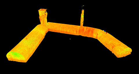
Iowa City Beer Caves LiDAR Scanning Project
The Iowa City Beer Cave (ICBC) LiDAR project is a collaboration by members of the University of Iowa community. This multi-discipline project includes members of the departments of Geographical and Sustainability Sciences, Classics, Anthropology and the Office of the State Archaeologist, Iowa Flood Center, and ICIGO - the undergraduate geographic outreach organization. We are interested in this space from a variety of angles ranging from training and application of the terrestrial LiDAR system, local geography and history, creation and interaction with virtual environments, and outreach. We extend a special thank you to Marc Moen for allowing us access to the site.
More information will be posted at this site as the project evolves so check back often.
 |
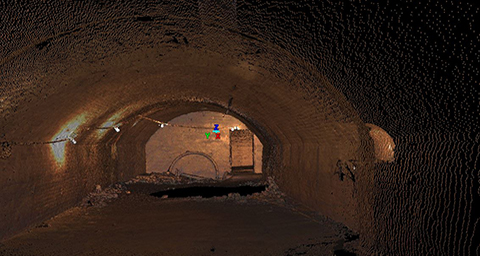 |
| Beer Cave Fly-through 1 - Intensity | Beer Cave Fly-through 1 - RGB Variant |
| We are: | ||
| Adam Skibbe | GIS Administrator | Department of Geographical and Sustainability Sciences |
| Dr. Sarah Bond | Assistant Professor | Department of Classics |
| Dr. Michelle Wienhold | GIS Analyst | Iowa Flood Center |
| Mark Anderson | Research Archaeologist | Iowa Office of State Archaeologist |
| Marlin Ingalls | Archaeological Historian | Iowa Office of State Archaeologist |
In the news:
Mapping Iowa City's beer caves - Iowa City Press-Citizen
Iowa City mapping beer caves with new technology - Cedar Rapids Gazette
Researchers studying underground tunnels in Iowa City - CBS Channel 2 Iowa
Iowa City Is Using Lasers To Map Its Abandoned Beer Caves - Atlas Obscura
Iowa City Maps Historic Beer Caves with LIDAR Scanning Tech - Government Technology
University of Iowa students and staff study below Iowa City streets - OurQuadCities.com